
Leg 159 Logging Summary
Shipboard Scientific Party
Leg 159 addressed the evolution of the Cote d'Ivoire/Ghana transform margin, one of the best-known examples of a former transform boundary between continental and oceanic crust. Transform faults are not as thoroughly understood as divergent and convergent margins; transform continental margins such as those in the Eastern Equatorial Atlantic have not previously been investigated by drilling. The specific objectives of this project were to investigate the deformation and sedimentation associated with the Cote d'Ivoire/Ghana transform margin and its development, to quantify its nature, structure and deformational history, and to place constraints on the opening of the oceanic gateway between the central and south Atlantic during the Cretaceous era.
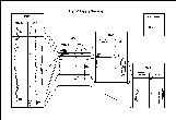
Logging data (summarized in Figure 1) were collected in four holes at three sites (Holes 959D, 960A, 960C and 962D), all located on continental crust on a ridge adjacent to the continent/ocean transition. The logs obtained correlate well with core measurements where core recovery was good. At Site 960, where two holes were logged, the logs provide measurements over sections of the holes where core recovery was particularly poor and core measurements rare.
Figure 1
Bridging and poor hole conditions prevented logging in the upper segment of Hole 959D but downhole measurements were successfully obtained over the lower part of the hole (395-1077 mbsf). The Schlumberger Quad, Formation MicroScanner (FMS), and Geochemical (GLT) toolstrings were run and the logs were of generally excellent quality apart from limited deterioration due to borehole wash-out near the top (405-424 mbsf) and bottom (1025-1045 mbsf) of the logged interval. The sonic and density logs were used to create a synthetic seismogram, which allowed increased precision of time/depth conversions of the seismic data. The boundaries separating the lithological units defined from core measurements are confirmed by changes in the logs at depths coinciding with these boundaries. An increase in micritization and a decrease in porcellanite, coinciding with a short term drop in clay content, is well-defined by a sharp rise in velocity and resistivity and an accompanying drop in porosity at approximately 750 mbsf (within Subunit IIC). The transition from the black claystone of Unit III to the sandstones at the top of Unit IV is also well delineated by most of the logs. Preliminary interpretation of the FMS data shows bedding planes dipping consistently towards NNW with dips increasing downhole from 5 to 14 degrees. Postcruise processing should improve the data and provide core orientation information which will allow the structural geologists and paleomagnetists to orient their measurements. The geochemical log data obtained at this site show good characterization of variable clay and carbonate compositional changes.
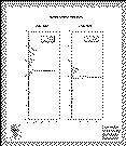
Following the end of logging operations, a short transit was made to Site 960, on the crest of the Marginal Ridge, three miles south of Site 959. Logging in Holes 960A and 960C was severely hampered by a combination of bridges and extreme borehole washout but provided valuable information over intervals where core measurements in both holes are infrequent due to poor core recovery. Bridging prevented the Quad toolstring from reaching the bottom of Hole 960A; the main log covered the interval 361.3-73.3 mbsf. Only one third of the logged interval was of a diameter less than 16 inches and these conditions seriously affected the quality of the sonic, density, and porosity data collected. Resistivity and gamma ray data may also have been affected, but to a lesser degree. The gamma ray log (Figure 2) shows an anomalously high reading, indicating high levels of uranium at approximately 185 mbsf, caused by phosphate nodules at that depth.
Figure 2
Neither the FMS nor GLT toolstrings were run at Hole 960A. At Hole 960C, a reduced Quad string measuring only natural gamma ray, resistivity, and sonic came within 5 m of total depth (logging 121.2-92.4 mbsf and 374.6-159.7 mbsf). Unfortunately, the borehole again was shown by the caliper curve to be washed out for well over half of the logged interval, resulting in poor quality sonic data. The gamma ray anomaly seen in Hole 960A was again well-defined in this hole at approximately 205 mbsf. Because of the importance of collecting structural data from the hole, the FMS was run in Hole 960C over the interval 354.5-173.7 mbsf despite the poor borehole conditions. Preliminary results indicate that the bedding is dipping NE with no evidence for increasing dip with depth. Although data quality was understandably poor, it may improve when processed onshore.
Bridging in Hole 962D prevented the reduced Quad toolstring from reaching the bottom 65 meters of the hole. The log covered 328-162 mbsf and a repeat log covered 306.5-173 mbsf. Approximately 50% of the logged interval was of a reduced Quad string measuring only natural gamma ray, resistivity, and sonic came within 5 m of total depth (logging 121.2-92.4 mbsf and 374.6-159.7 mbsf). Unfortunately, the borehole again was shown by the caliper curve to be washed out for well over half of the logged interval, resulting in poor quality sonic data. The gamma ray anomaly seen in Hole 960A was again well-defined in this hole at approximately 205 mbsf. Because of the importance of collecting structural data from the hole, the FMS was run in Hole 960C over the interval 354.5-173.7 mbsf despite the poor borehole conditions. Preliminary results indicate that the bedding is dipping NE with no evidence for increasing dip with depth. Although data quality was understandably poor, it may improve when processed onshore.
Bridging in Hole 962D prevented the reduced Quad toolstring from reaching the bottom 65 meters of the hole. The log covered 328-162 mbsf and a repeat log covered 306.5-173 mbsf. Approximately 50% of the logged interval was of a diameter greater than 14 inches, which seriously degraded the quality of the sonic data collected. The logged interval falls entirely within the deepest unit, which is of particular importance in ascertaining the deformational history of the margin. The FMS toolstring was unable to get past a bridge at 293 mbsf but approximately 100 meters (293-192 mbsf) was logged with two passes. The data was all collected within the oldest strata drilled and will provide essential structural information in the sandstones, siltstones, claystones and limestones which make up this unit, thought to be synchronous with the transform faulting episode.
Logging Team:
Lee Ewert and Carlos Goncalves
Univ. of Leicester Borehole Research Group