
Leg 174A Logging Summary
Shipboard Scientific Party
Introduction
Leg 174A is part of a multi-leg transect across the mid-Atlantic margin that includes drilling on the coastal plain (ODP Legs 150X and 174X), continental shelf (Leg 174A and planned future drilling) and on the continental slope and rise (ODP Legs 150 and 174A and DSDP Leg 96), with the main goal of investigating the record of sealevel changes in the sediments of a passive margin.
Leg Objectives
The main scientific objectives of Leg 174A are:
- to date as precisely as possible sequence boundaries of Oligocene to Pleistocene age, and to compare this stratigraphic record with the timing of glacial-eustatic changes inferred from deep-sea delta O-18 variations;
- to place constraints on the amplitudes and rates of sea-level change that may have been responsible for unconformity development;
- to assess the relationships between depositional facies and sequence architecture; and
- to provide a baseline for future scientific ocean drilling that would address the effects and timing of sea-level changes on this and other passive continental margins.
Operations and Data Summary
Three sites were drilled during Leg 174A, with locations shown in Figure 1. Two sites were drilled on the continental shelf in water depths of 88-90 m (Site 1071) and 98 m (Site 1072), and one site on the Hudson Apron continental slope (Site 1073 at 638 m). Difficult drilling conditions were encountered at both shelf sites, with hole instability caused by the presence of relatively thick, unconsolidated sandy intervals. A total of 283 m of core were recovered in 947 m drilled on the shelf sites, with intervals of up to 50 meters with little or no recovery in some holes.
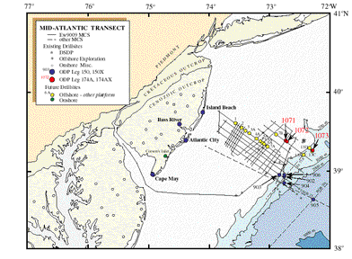
Figure 1: Location of ODP Leg 174A sites and other sites composing the Mid-Atlantic Transect.
At Site 1071 hole collapsing prevented wireline logging. Hole 1071G was spudded with LWD tools in the bottom-hole-assembly (BHA) but the BHA became stuck at 95 mbsf. After several hours stuck, the data and nuclear sources were retrieved with the LINC tool (a special wireline device), and eventually the BHA became free. No further logging was attempted at Site 1071. Site 1071 is located 1 km away from the COST-B2 stratigraphic test well. This well was cased down to 208 mbsf, and open hole logs below this point complement the data set for the Mid-Atlantic Transect.
After logging Hole 1072A with the triple-combo the hole collapsed preventing further deployments. Hole 1072B was logged with the sonic-resistivity, the FMS and with the check-shot tool. Holes 1072C and 1072D were drilled with the LWD bottom-hole assembly.
Nearly complete recovery was achieved in Hole 1073A on the continental slope south of the Hudson Canyon. Wireline logging required several tool runs due to impassable bridges encountered at various depths in the hole. One triple-combo run covered the lower portion of the hole, three tool runs provided complete sonic-resistivity-gamma ray coverage of the interval drilled, and two deployments of the check-shot tool provided good traveltimes for accurate depth-time conversion.
Table 1 contains a summary of the tool strings run at each hole with the respective depth intervals in meters below the seafloor, including the number of check-shot stations acquired (see Table 2 for tool string configurations). LWD (Logging While Drilling) and wireline logging data for this and other legs can be accessed online.
Table 1: Summary of Logging Runs
|
Tool String |
1071G |
1072A |
1072B |
|
Triple Combo-TLT |
X |
300-30 |
X |
|
Sonic Resistivity - TLT |
X |
X |
306-0 |
|
Formations Micro Scanner |
X |
X |
306-38 |
|
Check Shot |
X |
X |
296-58 (12) |
|
Logging While Drilling |
0-95 |
X |
X |
TABLE 2 - Tool string configurations (acronym descriptions).
|
Tool String |
Logging Tools |
|
Triple Combo - TLT |
HNGS/APS/HLDS/DITE/TLT |
|
Sonic Resistivity - TLT |
NGT/LSS/DITE/TLT |
|
Formation Micro Scanner |
NGT/GPIT/MESTB |
|
Check Shots |
WST |
|
Logging While Drilling |
CDN/CDR |
Logging highlights
Logging data played a critical role in achieving the leg objectives, in particular by providing traveltime data for precise tying of core and log depths to the seismic reflection profiles, and for estimating the lithostratigraphy and facies trends of the intervals drilled.
Continental Shelf Sites:
Wireline and LWD data on the shelf complement each other in that the LWD logs sample the uppermost sedimentary section that is out of reach of open-hole wireline measurements and that LWD provides measurements soon after the hole is cut (Figure 2). The wireline measurements on the other hand provided borehole images (FMS) and sonic logs. Differences between the wireline and LWD measurements, particularly resistivity, provide information on the lithology because borehole fluid invasion occurs primarily in the porous unconsolidated intervals (primarily sand-rich).
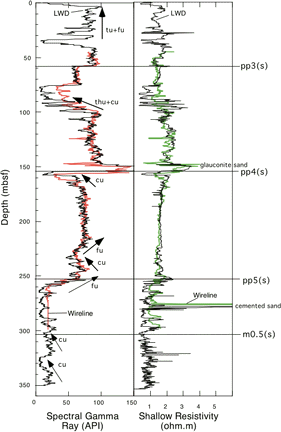
Figure 2: Wireline (color, Hole 1072B) and LWD (black, Hole 1072D) logs at Site 1072.
Gamma-ray and resistivity logs revealed the major changes in lithology and facies trends in the sands and shales drilled on the shelf (Figure 2). Large peaks in the gamma-ray log reveal intervals of glauconite-rich sands, which are easily discerned by the high potassium content (e.g., pp4[s] and to a lesser extent pp5[s]). The two sequences logged at Site 1072 show overall increasing gamma-ray in the lower part of the sequence (upward fining), and overall upward coarsening in the upper part of the sequence (Figure 2).
Formation MicroScanner images acquired in Hole 1072B provide detailed information on the facies and sedimentary structures that were not well preserved in most of the rotary-drilled cores. The image in Figure 3 illustrates the abrupt lithologic boundary at surface pp4(s) with sand and pebbles both above and below a lithified glauconitic sand bed. Figure 4 illustrates the bioturbated sediments rich in pyrite and resistive clasts (probably carbonate concretions and/or shells) encountered in the transgressive part of the shelf sequences as seen through the FMS images.
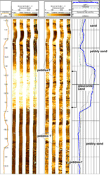
Figure 3: FMS image across interpreted sequence boundary pp4(s). Resistive interval in the middle is a glauconitic sandstone. Resistive clasts seen in the image are interpreted as pebbles and/or shells.
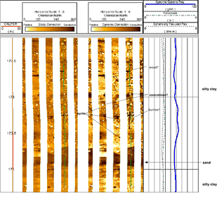
Figure 4: FMS image across interval below pp4(s).
A summary of the traveltime to depth conversion data available is shown in Figure 5. A high-resolution (~25 m interval) check-shot velocity function obtained at Site 1072 provided good interval velocities, generally consistent with the sonic log. The check-shot derived velocities are generally faster than those derived from seismic stacking, which tend to predict depths for the seismic reflections as much as 20 m deeper within the interval drilled. Synthetic seismograms generated with the corrected sonic log yield reasonable matches to the main reflection surfaces suggesting that the checkshot-derived time-depth conversion is a better choice.
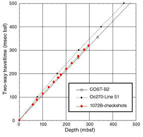
Figure 5: Comparison of traveltime-depth curves across the continental shelf sites.
Figure 6 shows a seismic reflection profile across the shelf transect together with the logging data displayed as a function of two-way traveltime. The two main sequences drilled, bounded above by pp4(s) and pp3(s), are dominated in this location by a relatively thick unit that thins in the seaward direction. These units generally fine upward (increasing gamma-ray) and core data shows that they also fine seaward. A small proportion of the sequences drilled are coarse grained (probably sands and pebbly sands with very low gamma-ray and appear to coarsen upward (e.g., Figures 3, and Figure 4). These units are clearly distinguished in the seismic reflection profiles by their overall offlaping and seaward thickening characteristics. The lower portion of the sequences are interpreted as part of the transgressive facies tract whereas the upper portion of the sequences are interpreted as part of the highstand facies tract. Little or no lowstand systems tract characteristics (onlapping geometry) are seen near the Leg 174A transect, except perhaps for a thin veneer immediately above surface m0.5(s) just landward of Site 1072.
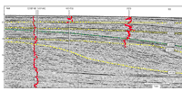
Figure 6: Interpreted seismic reflection profile (Oc270-Line 885) across the shelf transect holes
These characteristics, i.e., a thick transgressive package and a thin highstand (and little or no lowstand) probably result from a relative lack of accommodation space (due to the shallow-dipping underlying sequence boundary) and large sediment influx. This geometry contrast significantly with the underlying sequences (e.g., below m0.5[s]), where seaward of the clinoform front the accommodation space is sufficiently high to preserve a thick highstand package (dipping and offlapping surfaces). Little core was recovered from this interval and the LWD logs suggest the presence of nearly clay-free sediment, organized in two major coarsening upward cycles, about 20 m thick each (Figure 2). The resistivity log also displays a marked change below m0.5[s] with high-frequency variations suggestive of relatively thin bedding.
Hudson Apron Site:
Site 1073 was selected on the continental slope at a location where the Pleistocene interval was interpreted to be relatively thick, with good potential to providing a good stratigraphic record for this time interval. A total of 520 m of Pleistocene sediment was recovered at the site. The hole penetrated the underlying condensed interval spanning the whole Neogene. A summary of the main wireline logs obtained at the site is shown in Figure 7.
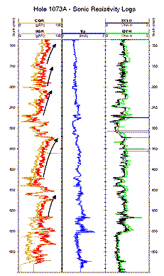
Figure 7: Summary of gamma-ray/sonic/resistivity logs at Site 1073.
The gamma-ray log reveals cyclic changes in clay content that are particularly prominent during the Pleistocene. The bulk of the sediment recovered at this site is comprised of clays and silty-clays with minor intervals of sand. We interpret the cyclic changes in grain size reflected in the gamma-ray log to result from the influx of coarser silt and sand grains during low-stands of sealevel followed by a gradual increase in the influx of clays as sealevel rose.
The Pleistocene cycles appear to correspond well with similar cycles seen in the pore water chemistry. The base of each of the cycles seen in the gamma-ray profile match closely with local minima in the chlorinity and alkalinity profiles. The cyclicity of pore water chemical species is possible because of the relatively rapid accumulation of sediments in the Pleistocene at this site. Integration of lithology from the cores and logs, pore water chemical profiles, stable isotope measurements and ages has the potential to provide a detailed record of the stratigraphic response of this slope site to climatic and sealevel fluctuations.
Figure 8 illustrated a traveltime versus depth comparison between the check shot data acquired in Hole 1073A with the integrated sonic log. The checkshot data was used to display the gamma-ray log onto the seismic reflection profile across the drill site (Figure 9). The cycles interpreted from the gamma-ray profile correspond well with the main seismic reflection boundaries interpreted on the basis of stratal geometry on the slope. The image shows our preliminary ties to sequence boundaries drilled on the continental shelf.
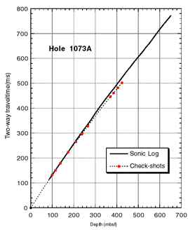
Figure 8: Comparison of check-shots and integrated sonic log traveltime-depth curves.
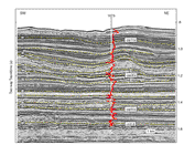
Figure 9: Interpreted seismic reflection profile (Oc270-Line 32, strike orientation) across Site 1073.
The sonic and resistivity logs suggest that the rapid accumulation of Pleistocene sediments on the Hudson Apron (average of ~65 cm/ky) prevented the underlying sediment to dewater and compact normally. The upper portion of the continental slope on the Hudson Apron, including the location at Site 1073, is largely devoid of large scale mass-wasting. Large scale mass-wasting however is seen to occur on the lower part of the slope. Integration of in-situ physical properties with the seismic reflection data may help shed light on whether the mass-wasting and sediment instability seen on the lower continental slope of the Hudson Apron is related to the Pleistocene sediment loading and associated changes in fluid pressures in the underlying sediments.
Logging Scientists:
Carlos Pirmez, Lamont-Doherty Earth Obeservatory
Gregory Mountain, Lamont-Doherty Earth Obeservatory
Candace Major, Lamont-Doherty Earth Obeservatory
Peter Flemmings, Penn State University
Heike Delius, RWTH, Aachen